For as long as people have looked up at the sky, clouds have served as nature’s weather forecast. Long before satellites, radar, and smartphone apps, farmers, sailors, and travelers relied on the shapes, heights, and movements of clouds to predict changing conditions. While modern meteorology has become remarkably precise, the sky still tells an incredible story to anyone who knows how to read it.
Clouds form when warm, moisture-rich air rises and cools, causing water vapor to condense into countless tiny droplets or ice crystals. The altitude, temperature, humidity, and atmospheric stability determine what type of cloud develops. Each cloud family is associated with particular weather patterns, making cloud identification a surprisingly useful skill.
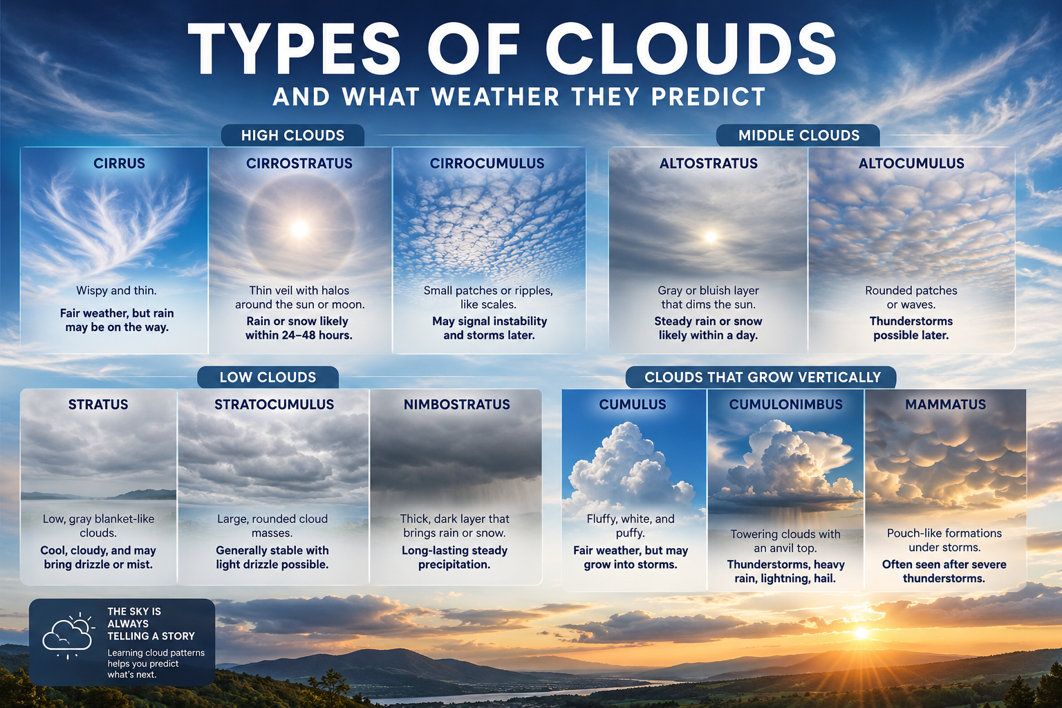
High-Level Clouds: The First Signs of Change
High clouds form between 6 and 13 kilometers (20,000–43,000 feet) above the Earth’s surface. At these altitudes, temperatures are well below freezing, so these clouds consist almost entirely of ice crystals. They rarely produce precipitation that reaches the ground but often announce changes in the weather.
Cirrus (Ci)
Cirrus clouds are the delicate, wispy strands that resemble feathers or horse tails stretching across a blue sky. They are among the highest clouds in the atmosphere and are often carried by strong upper-level winds.
Cirrus clouds usually indicate fair weather in the immediate moment. However, when they gradually increase in number and begin covering more of the sky, they often signal that a warm front is approaching. Rain or snow may arrive within the next 12 to 36 hours.
Cirrostratus (Cs)
These clouds appear as a thin, almost transparent white veil covering much or all of the sky. One of their most recognizable features is the halo they produce around the Sun or Moon, caused by sunlight passing through countless ice crystals.
A cirrostratus layer is one of the clearest indicators that widespread precipitation is approaching. Although the sky may still appear bright, rain or snow is often less than a day away.
Cirrocumulus (Cc)
Cirrocumulus clouds form small white patches or ripples arranged in rows, often resembling fish scales. This pattern is sometimes called a “mackerel sky.”
These clouds usually indicate atmospheric instability at high altitudes. While they do not produce rain themselves, they can precede unsettled weather or thunderstorms later in the day, especially during warmer months.
Middle-Level Clouds: The Atmosphere in Transition
Middle clouds develop between approximately 2 and 7 kilometers (6,500–23,000 feet). They often contain both water droplets and ice crystals and frequently accompany developing weather systems.
Altostratus (As)
Altostratus clouds create a smooth gray or bluish blanket that covers much of the sky. The Sun may still be visible but appears dim, as though viewed through frosted glass.
These clouds usually form ahead of warm fronts and signal prolonged periods of steady rain or snowfall. When an altostratus layer thickens over several hours, precipitation is becoming increasingly likely.